Beyond compliance: Next generation Integro™ LIDAR 3D Dust Monitoring Network

3D mapping brings data to life

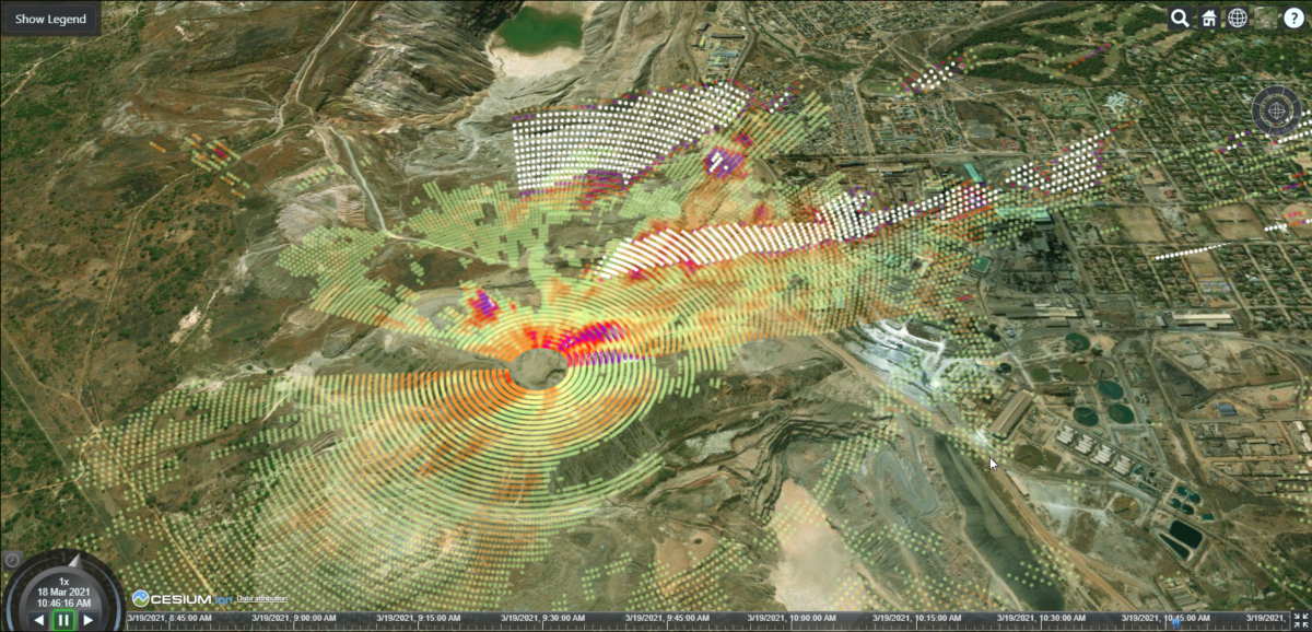
The transition from a static 2D interface to a 3D mapping platform in the next generation Integro™ LIDAR Network offers a whole new level of interactivity that empowers users.

The new interface is fully integrated into the Acoem Cloud web browser to give users a high-resolution Google Earth-like 3D viewing experience. This enhanced useability helps Integro™ LIDAR Network users transform monitoring data into informed action.

Visualise actual particulate concentrations and aerosol plumes from your site in 3D in near-real time. Zoom in or zoom out, scan up and down and look at the colour-coded data from above, from the side or any angle to identify hotspots or fluctuations.

Track dust behaviour from its emission source

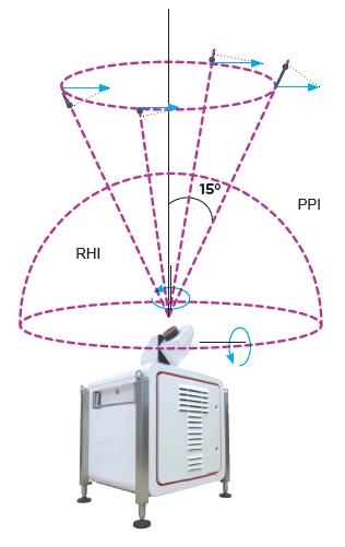
The Intergo™ LIDAR Network combines three or more fixed dust and meteorological stations with Acoem Airodis™ software, the Acoem Cloud and a Light Detection and Ranging (LIDAR) Leosphere Windcube® instrument which continuously scans an area and measures dust concentration and radial wind speed/wind direction.

It can be configured to complete several different scan types, including radial (PPI) and vertical (RHI) with a coverage area ranging from a few hundred metres up to 12 kilometres (24 kilometres scan diameter).

Figure 2: The Leosphere Windcube® LIDAR (Light Detection and Ranging) instrument is a vital part of the Acoem Integro™ LIDAR Network for measuring dust emission sources and dust movement over a scanned area up to 24 km in diameter.


LIDAR technology precisely identifies all dust emission sources and dispersion trajectories. The fixed stations measure dust concentration to regulatory standards plus wind speed and direction and the Integro™ LIDAR Network uses these measurements to correlate the scanned data.

Integro™ LIDAR Network is currently being used in some of the world’s harshest and most remote locations. Suitable for a variety of applications, including mining, ports, infrastructure construction and community engagement, the system gives users full visibility over the particulate and dust concentrations on site.

“The Integro™ LIDAR Network isn’t just a compliance solution. It has evolved to become a critical operational tool. Adhering to government regulated dust levels is important, but so too is having greater insight into the safety of your workers, the health of surrounding communities and conserving resources,” commented Acoem Engineering, Research & Development Manager, Grant Kassell.

“The additional benefits of the Integro™ LIDAR Network include using its real-time information to inform effective and targeted dust suppression measures like sending out water trucks and being able to identify the exact source of emission exceedances to support process changes or prioritise remedial actions,” he concluded.

Complete end-to-end services for better environmental outcomes

Acoem not only creates technology systems but it partners with like-minded innovators in environmental management, like Leosphere, the developers of the Windcube® LIDAR instrument, to provide holistic data-powered solutions and full end-to-end services.

Acoem’s highly skilled Environmental Reporting Services (ERS) team consistently oversees the Integro™ LIDAR Network to make sure that data captured is correct and validated. Because of changes in background and atmospheric conditions, ERS team members review the network daily and make any required LIDAR parameter changes. Acoem technicians also deliver on-the-ground support, managing maintenance issues and calibration for the Integro™ LIDAR Network so client organisations can concentrate on core business activities and make timely, accurate and informed operational decisions.

To find out how we can tailor an Acoem Integro™ LIDAR Network to suit your monitoring needs, visit www.acoem.com or contact Jošt Lavrič, PhD, Acoem Scientific & LIDAR Products Sales Manager.

Would you like to…?